091-5758564, 081-6679233 ,02 7035192
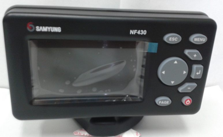
ดาวเทียม+ซาวเดอร์SAMYUNG N430, NF430 ,F430จอ4.3"
 เพิ่มเมื่อ: 2017-01-26 16:25:24.0
 แก้ไขล่าสุด: 2017-12-04 16:10:10.0
 เบอร์โทรติดต่อ: 091-5758564, 081-6679233 ,02 7035192
  อีเมลล์: ChotigaLim@gmail.com LINE ID.nisakornn1
ดาวsamyung 4.3" หัวพลาสติก ไม่มีเสาดาว
ดาวเทียม+ซาวเดอร์ SAMYUNG N430/ NF430/ F430
Wide 4.3” Color GPS / Combo/ Fishfinder
Wide 4.3” High resolution TFT LCD 128M Internal memory
Function by using icon for menu
Instruction Manual
DGPS (WAAS, MSAS, EGNOS)
Digital fishfinder technology (200 KHz, 300W)
Wide 4.3” Color GPS/ Combo/ Fishfinder
Features
- Wide 4.3” High resolution TFT LCD
- Fast screen response by high performance CPU
- 10 Steps adjustable including English, Chinese, Russian, Thai, Malay etc.
- DGPS (WAAS, MSAS, EGNOS)
- User-friendly operation type by using icon for each menu
- 128 MB internal memory and built-in standard Samyung chart
- NMEA0183 Interface (AIS, NAVTEX, DSC etc.)
- 2 split screens (Chart, Data, Highway etc.)
- Suitable for small fishing boat
- Using single frequency (200 KHz) for detection of small and individual fish
- Easy to use by auto gain
Specification
|
Spec Model |
N430 |
NF430 |
F430 |
|
Size |
127.5 mm (H)x 183 mm (W)x 91.5 mm (D) |
||
|
Display |
Wide 4.3” TFT color 480 x 272 pixels |
||
|
Supply voltage |
10 to 32 V DC |
||
|
Supply current |
13.8 V, 0.13Amin - no backlighting. 0.24A max - full backlight. |
||
|
Operating temp |
-10 ̊C ̴ 50 ̊C |
||
|
Alarms |
Arrival radius, anchor, XTE, danger, too shallow, too deep, fish, temperature, temperature rate, low battery, low fuel (optional), Loss of DGPS fix, radar guard zone, dangerous AIS vessels. |
||
|
User card |
SD Card |
- |
|
|
Waypoints |
10,000 Waypoints (Event Mark : 48, Mark :16) - |
||
|
Routes |
100 Routes, with up to 100 points each - |
||
|
Tracks |
By time or distance, 10 track of 15,000 points - |
||
|
Chart datums |
216 Chart datums (See next page) - |
||
|
Chart scale |
0.2 ̴ 500nm |
|
- |
|
Interface |
NMEA 0183 |
|
- |
|
Frequency |
- |
200KHz |
|
|
Output |
- |
300W |
|
|
Depth range |
- |
Min : 0m ̴ 3m, Max : 0m ̴ 150m |
|
|
Color display |
- |
16 colors / 8 colors |
|
|
Brightness |
- |
10 - step |
|
|
Screen moving speed |
- |
Super fast, fast, medium, low, stop |
|
|
Battery voltage display |
- |
Voltage number display |
|
|
Auto gain adjustment |
- |
OFF/ ON |
|
|
A-Mode display |
- |
OFF/ ON |
|
|
Demo display |
- |
OFF/ ON |
|
|
Weak color removal |
|
0 % ̴ 75 % STC |
|
Instruction Manual
N430 / NF 430
SAFETY INSTRUCTIONS
This device’s electronic chart system (ECS) is developed for the navigational aid only and chart itself does not obtain any approvals; has not been certified from the government authorities. If operator need safe navigation then must use an official chart that has been approved by government agencies also operator is fully responsible for using this device
Please read through this manual before the first operation. If you have any questions, please contact the customer service or your local dealer or distributor Extensive exposure to heat may result in damage to the chart plotter.
Connection to the power source with reversed polarity will damage the chart plotter severely. This damage is not covered by the warranty.
Do not disassemble. The chart plotter contains dangerous high voltage circuits which only experienced technicians must handle
Exposure of the display to UV rays may shorten the life of the liquid crystals used in you plotter. This limitation is due to the current technology of the LCD display.
Avoid overheating which may cease loss of contrast and, in extreme case, a when temperature decreases.
Screen Cleaning Precaution
Cleaning your chart plotter screen is a very important operation and must be done carefully. The following is the cleaning procedure.
You use a tissue or lens tissue and a cleaning spray containing Isopropanol (a normal spray cleaner sold for PC screens. Fold the tissue or lens tissue into a triangular shape, moisten the tip and use the index finger behind a corner to move the tissue across the surface, in overlapping side to side strokes. If the tissue is too wet, a noticeable wet film will be left in its path and you will need to repeat the process. If too dry, the tissue won’t glide easily, and may damage the surface.
Introduction
General Information
The chart plotter is a precision-crafted GPS chart Plotter with high-performance receiver for the Global Positioning System constellation of satellites, providing precise location data with a host of navigation features. Some functions require optional units and sensors installed on your boat
The chart plotter can be connected to external devices with NMEA0183 and NMEA2000 interface and display information Following are the example.
- NAVTEX
- AIS receiver
- DSC VHF radio
- Transducer & sensors
- Autopilot
Specification
N430, NF430
|
GENERAL |
||
|
Category |
Detail |
|
|
Size |
129 mm (H)x 183 mm (W)x 113.5 mm (D) |
|
|
Display |
4.3" Diagonal, TFT color, 480 x 272 pixels |
|
|
Supply Voltage |
10 ̴ 35 V DC |
|
|
Supply Current |
N 430 |
NF430 |
|
|
13.8 V |
13.8V |
|
|
130Ma – LCD no backlighting. |
270Ma - LCD no backlighting |
|
|
240Ma - full backlighting. |
400Ma – LCD full backlighing |
|
Operating temperature |
-10 ̊ ̴ 50 ̊C |
|
|
ALARMS |
||
|
User set: Arrival radius, anchor, XTE, danger, low battery, loss of DGPS fix, dangerous AIS vessels. |
||
|
GPS NAVIGATION |
||
|
Chart card |
NAVIONICES SD Card |
|
|
User card |
SD Card |
|
|
Waypoints |
Up to 10,000 with default or user defined alphanumeric names up to eight characters. |
|
|
Routes |
100 Routes, with up to 100 points each |
|
|
Tracks |
By time or distance, 10 track of 15,000 points |
|
|
Chart datums |
216 Chart datums, One user-defined map shift. |
|
|
Chart scale |
0.2 to 500nm for chart (chart dependent) down to 0.005 nm in plotter mode. |
|
|
COMMUNICATIONS |
||
|
NMEA |
NMEA 0183 baud : 4800, 9600, 38400 |
|
|
NMEA0183 Input from Compatible instruments |
DBK, DBS, DBT, DPT, GGA, GLL, GNS, GGA, GSV, HDG, HDT, MDA, MTA, MTW, MWD, MWV, RMC, RPM, VHW, VTG, VWT, ZDA |
|
|
NMEA0183 Output for Compatible instruments |
APA, APB, BWR, GGA, GLL, GSA, GSV, RMB, RMC, VTG, XTE, XDR,ZDA, PLT |
|
|
NMEA2000 Output for Compatible instruments |
Water Speed (128259),Water depth(128267), XTE (129283), NAV. Data (129284), NAV data (129285), COG & SOG (129026), GNSS position (129029), Water temp. (130310) |
|
|




 สินค้าที่เกี่ยวข้อง